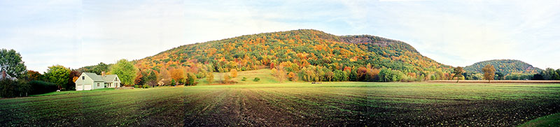
Mount Sugarloaf as it appears today, still overlooking the rich farmland of the Connecticut River Valley. Image courtesy of Pocumtuck Valley Memorial Association/Memorial Hall Museum.
The Pocumtuck story of the "Amiskwôlowôkoiak"—the people of the beaver-tail hill—is an example of a "deep-time story" with an "earthshaper" motif. Native stories in this genre describe, in metaphorical terms, using human, super-human, and non-human characters, how ancient geological events reshaped the landscape, forming mountains, rivers, lakes, islands and rocky outcroppings. Many of these stories also describe species evolution and climate change. Native oral narratives about the landscape formed part of a larger body of knowledge that enabled Native people to efficiently hunt, fish, gather and plant, make climate predictions, practice ethnobotany, and situate homesites in the best locations. In this story, there is a remarkable resonance between the familiar results of a beaver building a dam, the ancient history of glacial flooding, the presence of giant beavers in the region during the Pleistocene era, and a mountain that happens to be shaped like a beaver today.
The present-day town of Deerfield is laid out on a broad flat floodplain that was once filled, about 10-12,000 years in the past, with the waters of what is now called "Glacial Lake Hitchcock". This glacial lake extended up the Connecticut River Valley into present-day Vermont. The water was contained on the east by Pemawatchuwatunck, the "long, twisting mountains" now called the "Pocumtuck Range." The rocky outcrop at the southernmost end of the Pocumtuck Range was known as "Wequamps," meaning a place where a hill drops off. On the west are the Sunsick Hills, now called "West Mountain." On the south was the glacial dam called "Rocky Hill Dam," near present-day Rocky Hill, Connecticut. A series of earth movements broke open the dam and allowed Lake Hitchcock to drain. When the Pocumtuck Range is seen from the top of nearby Mt. Tom or from the ground in South Deerfield, it resembles the shape of a beaver swimming in the water with its legs submerged.
Although Lake Hitchcock was too large to have been literally shaped by a beaver, there are other lakes across the continent that were formed by giant beavers. The extinct species Castoroides ohioensis averaged nine feet long (not including the tail) and 700 pounds, compared to the modern beaver, Castor canadensis, who averages only two feet, with the tail, and 60 pounds. When beavers first construct dams, their ponds fill with fresh water, but after silt forms, the waters stagnate and the beavers move on. Old beaver ponds eventually drain and fill in to form "beaver meadows." A few beaver ponds remain as lakes, such as "Beaver Lake," in Yellowstone, created by a Pleistocene-era beaver dam that once measured 700 feet long.
There are many stories of giant beavers among Algonkian peoples in New England and Canada, and they seem to occur with the greatest frequency where glacial lakes were found. Topographical modifications are often attributed to transformer characters such as Gluskabe (Wôbanaki), Maushop (Wampanoag) and Nanbhozo (Anishinabe). Parts of the landscape that resemble particular animals or objects serve as mnemonic devices and tangible places that represent the proof of past actions. In one Malecite story, the transformer Gluskap chases a beaver across Canada, "to the St. Lawrence River where it built a great dam which created the Great Lakes." In a story from Nova Scotia, a shapeshifting shaman turns into a beaver. Another story describes how Gluskap formed Nova Scotia while he was chasing a giant beaver. He left behind a broken canoe, a cooking pot, a moose, a dog, and beaver's entrails, all of which are visible as rocks and islands today.
Excerpted from the Raid on Deerfield: the Many Stories of 1704 website.